Is there a backstory here?I never really liked the 'dominion' colouration. IMO the dominions were virtually completely independent nations, even getting their own separate negotiating seats at the table after both world wars. They followed Britain's lead but that's only natural for fledgling nations. I don't think they need a special representation on a map when simply colouring them independent is just as accurate.
I've done most of Europe:
View attachment 901428
There are obviously departures from Bruce's version, hence why I can't really say I'm mimicking it as much anymore. I guess it's rather my own spin. For example, in Bruce's version Italy was unified, but here it isn't, and Britain controlled the Flanders portion of Belgium, whereas here the 'Kingdom of Germany' (as he called it, I think 'German Empire' works just fine though) controls all of it. Likewise, Britain also puppetised Denmark and Norway and controlled Pomerania in his version, but I can't help but feel like that's extreme. Instead Britain's territorial extent in Europe is Hanover (with the Free City of Bremen contained within), Calais, Gibraltar, Minorca, Malta, and Cyprus. One thing I did keep was Russia's dominance in the Balkans. I'm also not sure what to do with Prussia. On the hand hand, integrating it into Poland-Lithuania makes sense, but on the other, I don't like how it looks aesthetically. Same conundrum with Courland.
You are using an out of date browser. It may not display this or other websites correctly.
You should upgrade or use an alternative browser.
You should upgrade or use an alternative browser.
WIP Map Thread
- Thread starter B-29_Bomber
- Start date
-
- Tags
- work in progress
Nah, that's not really my thing.Is there a backstory here?
I always have a vague idea in mind - e.g., for this one, perhaps no American Revolution or a failed revolution or something eventually leading to this, or perhaps a different result in the 7 Years War or something - but I don't really flesh it out. When I do notes, it's always more "how things are in the present (time of the map)" with vague allusions to events that might have happened previously (such as a war in Europe, resulting in Russia dominating the Balkans, the Ottoman Empire imploding, and France losing the low countries to Germany or something).
Is that British America?
It’s the Imperial Dominion of North America so yeah, British America.Is that British America?
A river map of Atlantis in a TL with alternate geography that I'm working on. I'm not sure who would settle it first (Berbers? Phoenicians? Greeks? Romans?), but I am having it be an expy of OTL North America (OTL North America has (mostly) the same geography, and was never colonised by Europeans save for the islands of Newfoundland, *Labrador, and the green islands in the Grand Banks).
A World in Ruins
The New World and the Old, c. 1923
The New World and the Old, c. 1923
This is an incomplete draft of a map inspired by a number of different sourceworks.
This began life as an attempt to develop a homebrew playmat for my Axis & Allies gaming group. The idea was to increase the variability of game play by introducing new theaters of war.
As I worked on backstory, I found that I was mostly inspired by Grey Wolf's "A Feast of Eagles" story (shared here more than twenty years ago), a similar story called Cherry Trees Spared (I searched for a copy but it led me to a link I won't share due to a cybersecurity warning), Shaytana's "Lux Invictus" project for Crusader Kings II, Harry Turtledove's "How Few Remain," and even the short-lived 2009 NBC television series, Kings.
Long story short...
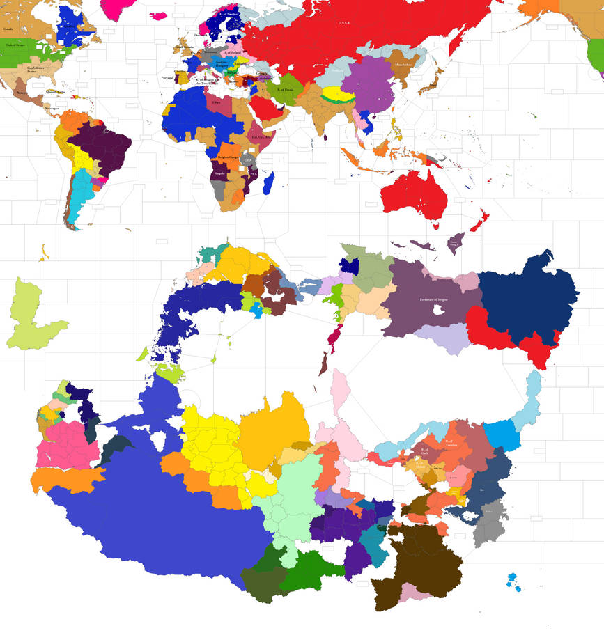
- Alexander the Great doesn't die in 323BC, but goes on to explore the Arabian coast, the east coast of Africa, and thence the northern coast of a vast new continent called Shamash. He arrives with a host of approximately 30,000 at a time of civil war, establishes himself as a local warlord, and is eventually crowned monarch of Atria, the large blue blob at the bottom of the map, which during Antiquity controlled the entirety of the left half of Shamash.
- Alexander did not die in Shamash; rather, he returned to Asia after a period of many years and eventually died there.
- Alexander's example tempted many of his generals to follow in his footsteps, and their smaller armies contained a multitude of cultures and religions, including Jews, early Christians, and Bhuddists.
- Shamashi culture is a fusion of Hellenistic, Judaic, early Christian, and local customs and traditions.
- Shamash is probably three decades behind Europe and North America technologically (electrification and railroads are both still rare) but avoided colonization due to factors including: endemic disease that stalled European conquest, very high levels of state organization that translated into effective military mobilization potential, competent navies. Due to the great distances involved, cavalry, river battleships, and more recently, the aeroplane, airships, and armored trains, feature prominently in local warfare.
- Both Atria and the collapsed Carmelite empire (the pink stuff on the lower right-hand side of Shamash) are hydraulic empires in the flavor of Karl August Wittfogel, and Shamashi engineering is superior to that of the Old World.
- In North America, France keeps Quebec after the Seven Years' War. The Confederacy emerges victorious in 1863 and 1882 with significant assistance from the British and French.
- In South America, the Spanish keep hold of Peru and the Portuguese of Brazil. Paraguay wins the War of the Triple Alliance be delaying the invasion of Brazil and Argentina until it has received the ironclad warships and artillery that were on order in OTL, allowing Solano López to better consolidate his early battlefield victories in Mato Grosso and Corrientes.
- In Europe, neither Italy nor Spain have ever unified. Belgium never became independent. The Central Powers eke out a victory during the Great War and Aragon takes a huge bite out of France by exploiting the distraction of the Western Front. The Ottoman Empire collapses and Greece continues to fight a long war in Anatolia with the flagging assistance of the Allies. Russia is roiled by Civil War. Kolchak has established himself in the Far East, with viable fronts also forming around Murmansk and in the Caspian. Poland has been created by the Germans and Austro-Hungarians as a buffer state against the Russians. It is now at war with a muscular Sweden.
Looking for folks interested to do some collaborative world-building or map-making! I'm always excited to answer questions about the setting.
Last edited:
I am looking for resources that gives very accurate map of the glaciers at glacial maximum, at equirectangular and 5000 pixels (4k-5k) in width or more
But there clearly is a Japan?
Is that big green state Turkic or Mongol?
Also that's a thicc China reaching all the way to the Caspian.
London is a French exclave in England?
Big Lithuania and/or Kievan Rus is also very cool.
More progressMan in the High Castle crossed with Years of Rice and Salt
If anyone has a good idea for what should go into that white space, let me know.
I found one. Anyone have something I should elaborate on before declaring this done?
Why is the world represented in this upside down (from our perspective) format?View attachment 904361
I found one. Anyone have something I should elaborate on before declaring this done?
I'm trying to make a map of the Imperial/Catholic victory in the Thirty Years' War.

Far from easy, I'm running out of maps to base it on...
Far from easy, I'm running out of maps to base it on...
I thought medieval Islamic maps were usually set up so the South was at the top, so I ran with that.Why is the world represented in this upside down (from our perspective) format?
Oh well that's interesting because I have noticed that other people have done that too but I hadn't immediately recognized the PoD here.... is China an Islamic country?I thought medieval Islamic maps were usually set up so the South was at the top, so I ran with that.
No, this is "Years of Rice and Salt" but where the Muslims win the Long War. (Grateful to Unkown00 for the base map)Oh well that's interesting because I have noticed that other people have done that too but I hadn't immediately recognized the PoD here.... is China an Islamic country?
Oh. I don't know enough about that story to know more than that war being like a super-lomg WW1?No, this is "Years of Rice and Salt" but where the Muslims win the Long War. (Grateful to Unkown00 for the base map)
Share: